|
|
|
 |
Technical paper required by the rules of the DARPA Grand Challenge Competition for 2004. |
|
U.S. GOVERNMENT RESTRICTED RIGHTS. UNPUBLISHED–RIGHTS RESERVED UNDER THE COPYRIGHT LAWS OF THE UNITED STATES. Use, duplication, or disclosure by the U.S. Government is subject to restrictions set forth in FAR Section 52.227-14 Alt. III (g)(3), FAR Section 52.227-19, DFARS 252.227-7014 (b), or DFARS 227.7202, as amended from time to time. These restrictions expire on March 13, 2004, after which time this document may be freely republished. |
|
This is the technical paper required by the rules of the DARPA Grand Challenge Competition for 2004. Submitted by Team Overbot info@overbot.com Revision 3 of September 22, 2003. [The Government's questions from revisions 1 and 2, along with our replies, appear at the end of this document. In addition, per the Government's request, the replies have been incorporated into the text, in bold italic.]
|
|||
|
|
1 |
Describe the means of ground contact. Include a diagram showing the size and geometry of any wheels, tracks, legs, and/or other suspension components. |
|
|
|
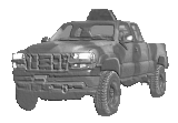
The vehicle is a commercial 6-wheel-drive all terrain vehicle, a Polaris Ranger Series 11 manufactured by Polaris Industries of Minneapolis, MN., diagrams of which are incorporated by reference. The front four wheels are on independent swing arm suspensions, and the rear axle is rigid, but on a swing assembly.
The overall vehicle weight, fueled, will be approximately 1900 pounds. |
||
|
2 |
Describe the method of Challenge Vehicle locomotion, including steering and braking. |
||
|
|
The front two wheels are steered, four of the wheels are equipped with hydraulic brakes, and all wheels are driven when in 6WD mode. |
||
|
3 |
Describe the means of actuation of all applicable components. |
||
|
|
The vehicle uses servomotors to actuate steering, brake, transmission, and throttle. The engine choke is actuated with a solenoid. The laser rangefinder atop the vehicle is actuated, in tilt only, by a servomotor. An electrical/vacuum system switches the vehicle from 2WD to 6WD. |
||
|
|||
|
|
1 |
What is the source of Challenge Vehicle power (e.g., internal combustion engine, batteries, fuel cell, etc.)? |
|
|
|
1-cyl 4-stroke gasoline engine, with additional 3KW gasoline-driven generator. |
||
|
2 |
Approximately how much peak power (expressed in Watts) does the Challenge Vehicle consume? |
||
|
|
About 35KW. |
||
|
3 |
What type and how much fuel will be carried by the Challenge Vehicle? |
||
|
|
39 gal. gasoline. |
||
|
4 |
Does the system refuel during the Challenge? (If so, describe the refueling procedure and equipment.) |
||
|
|
No. |
||
|
|||
|
|
1 |
What kind of computing systems (hardware) does the Challenge Vehicle employ? Describe the number, type, and primary function of each. |
|
|
|
The vehicle carries three small industrial control microcomputers for sensor and actuator control, and two larger computers for vision and navigation processing. All computers are IA-32 architecture. Interconnection is via 100baseT networking. |
||
|
2 |
Describe the methodology for the interpretation of sensor data, route planning, and vehicle control. How does the system classify objects? How are macro route planning and reactive obstacle avoidance accomplished? How are these functions translated into vehicle control? |
||
|
|
The overall approach is to measure terrain and obstacles, and build from this information a local terrain map of the immediate vicinity of the vehicle. The vicinity map is probabilistic and contains uncertainty information. An attractive/repulsive field type planner is used to generate trajectories. In addition, a visual road follower attempts to recognize road surfaces and add them to the vicinity map, so that if a road is present and going in the desired direction, it will be used. At a lower level, processing algorithms for individual sensors exert veto power over high-level decisions, which may result in the vehicle stopping suddenly if an obstacle is detected. At a higher level, the vehicle will generally head toward the next waypoint unless it has encountered an obstacle in doing so. It will then mark untraversable areas in its vicinity map, and will attempt to work around them, backing up if necessary.
|
||
Our general approach is to not out-drive our stopping distance. We insist on good ground profiling data from the laser rangefinder out to our stopping distance. Pitch will be factored into the stopping distance computation, and rough ground will be covered at slower speed so that the vehicle sees shock levels well under 1G vertically. We will not exceed 40MPH at any time.Escaping from local minima is the job of the "higher level" processing referred to under "Processing", above. Internally, we call this the "backseat driver", because it has no direct authority over the control system. The backseat driver can replace the current goal point with a temporary subgoal, which is then used by the potential field planner. This can result in backing up if necessary.
The "backseat driver" uses a simple route-finding algorithm similar to the well-known "A*" algorithm. It maintains a larger-scale "vicinity map" covering an area that contains at least the previous and next waypoints. The data in this map is a lower-resolution version of that in the potential field map.
In general, route-finding in difficult situations will not be successful on the first try, because the available information about the terrain will initially be insufficient. Untraversable terrain will be marked as such in the larger-scale vicinity map and not explored again, so eventually the vehicle should find a usable route, if one exists within the allowed boundaries. This process may be slow. |
|||
|
|||
|
|
1 |
What types of map data will be pre-stored on the vehicle for representing the terrain, the road network, and other mobility or sensing information? What is the anticipated source of this data? |
|
|
|
The primary map data carried is a high-precision road map, representing the location of roads in the area. Terrain data, in the form of publicly available 20 meter DEM data, may also be carried, but will not be used extensively. We are currently using Keyhole Corporation's imagery database. We will only carry roadmap data on the vehicle, but we may do some preprocessing using the imagery to align the roadmap data more accurately with the imagery. |
||
|
|||
|
|
1 |
What sensors does the Challenge Vehicle use for sensing terrain? For each sensor, give its type, whether it is active or passive, its sensing horizon, and its primary purpose. |
|
|
|
An Eaton VORAD anti-collision radar system is fitted to detect collisions with other vehicles and large obstacles. This unit can sense car-sized targets at up to 100 meters, but is much more limited in range when sensing less solid targets. This is primarily a backup system to prevent hitting other vehicles. The radar unit is a standard Eaton VORAD unit, the widely used truck anti-collision radar, interfaced to computers using an Eaton VBOX. The unit has a nominal range of 100 meters, and returns range, range rate, and azimuth over a serial link.
The primary sensor is the well-known SICK LMS 221, mounted high on the vehicle on a semi-custom tilt head. Its purpose is to profile the ground ahead, not merely detect obstacles. This is an active sensor with a maximum useful range of 45 meters. This range is reduced on dark surfaces. We are continuing to explore options for a longer ranged laser rangefinder, and will inform DARPA should we obtain one.
The camera is used by a road-following vision system. If the vehicle is on a road, and the road goes towards the next waypoint, road-following will be used. Our current digital camera is a Unibrain Fire-I 400, which is a 640x480 industrial camera.
The usual ring of ultrasonic sonars is provided, with overlapping sensing fields surrounding the vehicle. These are primarily for protection during low-speed operation, and for detection of obstacles alongside the vehicle. These are active sensors with a 3 meter or so range. In addition, there are narrow-angle sonars pointing down ahead of each leading wheel and behind each trailing wheel. These are used to check supporting terrain during low-speed operation.
Water sensors at two heights are provided to detect when the vehicle has entered water. These are simple conductive sensors. One is installed as low as possible without impairing terrain clearance, and a second is installed just below the fording depth limit |
||
|
2 |
How are the sensors located and controlled? Include any masts, arms, or tethers that extend from the vehicle. |
||
|
|
The laser rangefinder sits atop the vehicle and is actively servoed in tilt. All other sensors are fixed. |
||
|
|||
|
|
1 |
What sensors does the Challenge Vehicle use for sensing vehicle state? |
|
|
|
All actuators have position and velocity feedback. Engine RPM and driveshaft RPM are monitored, along with some voltages and temperatures. A Doppler radar speedometer senses vehicle speed relative to the ground. A low-precision strap-down INS and magnetic compass are provided for short-term acceleration, velocity, and position sensing. |
||
|
2 |
How does the vehicle monitor performance and use such data to inform decision making? |
||
|
|
Vehicle speed as measured by the radar speedometer is compared with vehicle speed as measured at the driveshaft to detect slippage. Engine RPM is compared with throttle setting to check engine load. Overheat conditions are detected and used as an indication to reduce speed. INS and GPS data are combined to maintain both a position relative to recent positions for local navigation, and an absolute position for global navigation. |
||
|
||||||||||||
|
|
1 |
How does the system determine its geolocation with respect to Route Waypoints? |
|
|||||||||
|
|
We are currently planning to use a Novatel ProPack LBHP GPS with Omnistar corrections, along with a Crossbow AHRS inertial system. This combination should give us location to within 20cm with GPS information available, and in dead-reckoning mode, we expect to have drift rates of perhaps 1 degree per minute in heading. We have not yet verified these figures in the field, and plan to do so well before the event. |
|||||||||||
|
|
|
|||||||||||
|
2 |
How does the system handle GPS outages? |
|||||||||||
|
|
The INS system and magnetic compass will take over, but drift is to be expected. If GPS is lost while on a well-defined road, or in an area where there is no alternative path, the road-following and collision-avoidance systems should be sufficient to keep the vehicle on course. Long GPS outages will result in increasing uncertainty as to position and, if this occurs in an area where the course boundaries are narrow, this may result in problems. For safety reasons, speed will be reduced during GPS outages. |
|||||||||||
|
3 |
How does the system process and respond to Challenge Route boundaries? |
|||||||||||
|
|
Specified route boundaries go into the vicinity map as limits beyond which the vehicle is not allowed to go. Physical route boundaries which can be sensed by any of the sensors will also be respected. Both the sonar and LIDAR units should be able to detect anything as solid as a plastic fence. |
|||||||||||
|
||||||||||||
|
|
1 |
Will any information (or any wireless signals) be broadcast from the Challenge Vehicle? This should include information sent to any autonomous refueling/servicing equipment. |
|
|||||||||
|
|
The vehicle will have a changeable display sign in the rear for communication with the chase vehicle. This provides minimal one-way communication without the need for a telemetry link. We have separate brake lights, as required. The display will display various short status messages, such as "Backing up", "GPS lost", and other messages useful to DARPA's chase vehicle. We do not contemplate using this for advertising purposes. |
|||||||||||
|
2 |
Other than GPS and the E-Stop signal, will the Challenge Vehicle receive any wireless signals? |
|||||||||||
|
|
Publicly available GPS augmentation signals such as WAAS, or a similar commercial signal (such as OmniStar) , will be used. |
|||||||||||
|
||||||||||||
|
|
1 |
Does the system refuel during the race? (If so, describe the refueling procedure and equipment.) |
|
|||||||||
|
|
No. |
|||||||||||
|
2 |
Are any additional servicing activities planned for the checkpoint? (If so, describe function and equipment.) |
|||||||||||
|
|
No. |
|||||||||||
|
||||||||||||
|
|
1 |
How will the Vehicle be controlled before the start of the Challenge and after its completion? |
|
|||||||||
|
|
The vehicle is manually driveable by an onboard driver, although at reduced speed. |
|||||||||||
|
2 |
If it is to be remotely controlled by a human, describe how these controls will be disabled during the competition. |
|||||||||||
|
|
n/a |
|||||||||||
|
||||||||||||
|
|
1 |
What tests have already been conducted with the Challenge Vehicle or key components? What were the results? |
|
|||||||||
|
|
As of August 1, 2002, our test results are as follows. The unmodified vehicle has been tested with a human driver on mountainous private property near San Jose, CA. We are satisfied with the basic off-road performance of the chassis. The VORAD radar has been mounted on the vehicle and tested in our test yard (a 1 acre fenced area in an industrial park in Redwood City, CA ), It detects buildings and cars at 50 meters, and chain link fences at about 8-10 meters. The system is quite good at detecting cars, but not particularly good at detecting fixed obstacles. This is consistent with the unit's design goals. The SICK laser rangefinder has been tested against various targets, and its limited range limits the speed at which we can drive. It does handle staring into the sun quite well; only a few pixels are lost looking directly into the sun. The road-follower software has been tested against video recordings of desert roads, with marginally satisfactory results. The imagery used was too narrow. The road follower is being revised and will be retested with wider-field imagery. |
|||||||||||
|
||||||||||||
|
|
1 |
What tests will be conducted in the process of preparing for the Challenge? |
|
|||||||||
|
|
We plan extensive testing in our small test yard, and once the system is working satisfactorily in that environment, we plan to test it on private property. Early testing will be on flat surfaces, followed by simple artificial obstacles such as railroad ties and traffic cones. More challenging off-road tests will follow. We intend to run the vehicle 250 miles nonstop, autonomously, at least once before the Grand Challenge. This may be round and round a closed course. |
|||||||||||
|
||||||||||||
|
|
1 |
What is the top speed of the Vehicle? |
|
|||||||||
|
|
About 40MPH on a flat road. |
|||||||||||
|
2 |
What is the maximum range of the vehicle? |
|||||||||||
|
|
250-350 miles. |
|||||||||||
|
2 |
List
all safety equipment on-board the Challenge Vehicle, including |
|||||||||||
|
|
|
|||||||||||
|
||||||||||||
|
|
1 |
How does the Challenge Vehicle execute emergency stop commands? Describe in detail the entire process from the time the onboard E-Stop receiver outputs a stop signal to the time the signal is cleared and the vehicle may proceed. Include descriptions of both the software controlled stop and the hard stop. |
|
|||||||||
|
|
Loss of the E-stop radio signal, its turn-off at the remote transmitter, or a soft stop ("freeze") command will cause a software-controlled vehicle stop. The throttle will immediately be retarded to idle. Hard braking will be applied under computer control. During emergency stop, steering will remain under computer control, but may be limited to a narrower steering range. The intent is to maintain limited steering control during emergency stop. Once the vehicle has come to a complete stop, the warning horn will be silenced, but the yellow flashing lights will remain active. The engine may be stopped if the vehicle is left in this state for an extended period, but can be restarted autonomously. Upon resumption of radio reception, or release from a soft stop ("freeze") command, the following events occur: The engine is restarted, if necessary. A short delay occurs while the vehicle sensors re-map the surroundings of the vehicle. The warning horn sounds continuously for five seconds. The vehicle begins to move, sounding the warning horn intermittently. Restart should require 30 seconds to 2 minutes, depending on whether we have to (autonomously) restart the engine. (The vehicle is surprisingly hard to start.) The display will provide status information to the chase vehicle during the restart process, to avoid surprises. The hard-E-stop radio signal ("kill") will cause the following events: Ignition and fuel pump power are cut off, killing the engine. The auxiliary generator is stopped. Control power is cut off, removing power from all computers and actuators. The emergency brake relay will drop out, causing the DC servomotor operating the brake actuator to operate as an ordinary motor to force the brakes into full lock. This motor is stopped by a pressure switch in the hydraulic line. The brake servo gear drive (a leadscrew) is not back-driveable, so the brakes remain mechanically locked. Power for this operation comes from a battery. The warning horn will be silenced, the yellow flashing lights will go out, and the vehicle will be electrically dead. |
|||||||||||
|
3 |
Describe the manual E-Stop switch(es). Provide details demonstrating that this device will prevent unexpected movement of the Vehicle once engaged. |
|||||||||||
|
|
Three industrial red emergency stop pushbuttons are provided, one on each side of the vehicle and one in the rear of the vehicle. Pressing any of them will actuate the sequence for a radio emergency stop as described above, and will immediately kill the engine as well. |
|||||||||||
|
4 |
Describe in detail the procedure for placing the vehicle in "neutral", how the "neutral" function operates, and any additional requirements for safely manually moving the vehicle. Is the vehicle towable by a conventional automobile tow truck? |
|||||||||||
|
|
The vehicle's transmission contains a centrifugal clutch, so when the engine is stopped, the transmission is effectively in neutral. But, after an emergency stop, the vehicle's brakes are locked. The procedure for towing the vehicle in emergency conditions is as follows. |
|||||||||||
|
|
|
|
||||||||||
|
|
||||||||||||
|
||||||||||||
|
|
1 |
Itemize all devices on the Challenge Vehicle that actively radiate EM energy, and state their power output. (E.g., lasers, radar apertures, etc.) |
|
|||||||||
|
|
SICK LMS 221 laser rangefinder - manufacturer-certified as eye-safe. The laser rangefinder (SICK LMS 221-30206) is listed by the manufacturer as "Class 1, eye-safe", and is a near IR laser. We do not know the exact wavelength of the laser beam at this time, but are aware that DARPA has procured these units on other projects and may possess this information.
Emits 5mw at 24.725GHz..
|
|||||||||||
|
2 |
Itemize all devices on the Challenge Vehicle that may be considered a hazard to eye or ear safety, and their OSHA classification level. |
|||||||||||
|
|
SICK
LMS 221 laser rangefinder - manufacturer-certified as eye-safe. |
|||||||||||
|
3 |
Describe safety measures and/or procedures related to EM radiators.. |
|||||||||||
|
|
Hearing protection should be worn near the vehicle. |
|||||||||||
|
||||||||||||
|
|
1 |
Describe any Challenge Vehicle properties that may conceivably cause environmental damage, including damage to roadways and off-road surfaces. |
|
|||||||||
|
|
The vehicle is of modest size and should have less impact than any road-licensed motor vehicle. |
|||||||||||
|
2 |
What are the approximate physical dimensions (length, width, and height) and weight? |
|||||||||||
|
|
2m wide, 3m long, 2m high.
Our current height measurement is 2.4 meters, or just under 8 feet. This gives us a 1' clearance under the low underpass. |
|||||||||||
|
3 |
What is the area of the vehicle footprint? What is the maximum ground pressure? |
|||||||||||
|
|
Assuming a tire contact patch of 25 square inches on a hard surface, the maximum vehicle ground pressure is 10psi. |
|||||||||||
|
|
||||||||||||
Appendix 1
DARPA's comments of August 22, 2003, with our replies.
|
Item |
Accepted |
Rejected |
Questions |
Notes |
|
Mobility |
|
|
X |
What is the overall weight of the vehicle? Any modifications to the suspension should be noted.
Reply: The overall vehicle weight, fueled, will be approximately 1900 pounds. This is well within the capacity of the stock suspension of the Polaris Ranger, which we have not modified, other than to add puncture-resistant tires. |
|
Power |
X |
|
|
|
|
Processing |
|
|
X |
The maximum speed that the vehicle can travel will be dictated by terrain, turning rate, etc. How will the set-point speed of the vehicle be decided?
Reply: Our general approach is to not outdrive our stopping distance. We insist on good ground profiling data from the laser rangefinder out to our stopping distance. Pitch will be factored into the stopping distance computation, and rough ground will be covered at slower speed so that the vehicle sees shock levels well under 1G vertically. We will not exceed 40MPH at any time. |
|
Internal Databases |
X |
|
|
|
|
Terrain Sensing |
|
|
X |
Please provide technical specs (and/or manufacturer and model name if a commercial product) of the digital camera. When available, details of the custom built laser rangefinder should be submitted as a technical paper addendum.
Reply: Our current digital camera is a Unibrain Fire-I 400, which is a 640x480 industrial camera.
We are continuing to explore options for a longer ranged laser rangefinder, and will inform DARPA should we obtain one. |
|
State Sensing |
|
|
X |
Please provide technical specs (and/or manufacturer and model name if a commercial product) of the Doppler radar unit.
Reply: The radar unit is a standard Eaton VORAD unit, the widely used truck anti-collision radar, interfaced to computers using an Eaton VBOX. The unit has a nominal range of 100 meters, and returns range, range rate, and azimuth over a serial link. |
|
Localization |
|
|
X |
Details of the INS are required, including estimated precision and drift rates (simply state brand and model name if it is a commercial product). Paper should demonstrate a localization capability that will be sufficiently precise to keep the vehicle within the course boundaries, which in some areas may be as narrow as 10 feet.
Reply: We are currently planning to use a Novatel ProPack LBHP GPS with Omnistar corrections, along with a Crossbow AHRS inertial system. This combination should give us location to within 20cm with GPS information available, and in dead-reckoning mode, we expect to have drift rates of perhaps 1 degree per minute in heading. We have not yet verified these figures in the field, and plan to do so well before the event. |
|
Communications |
|
|
X |
What information is being displayed on the sign on the rear of the vehicle? Only a brake light is required (see rule 6.4.2.3). This brake light indication must be clear and separate from any other changing displays.
Reply: We have separate brake lights, as required. The display will display various short status messages, such as "Backing up", "GPS lost", and other messages useful to DARPA's chase vehicle. We do not contemplate using this for advertising purposes. |
|
Autonomous Servicing |
X |
|
|
|
|
Non-autonomous control |
X |
|
|
|
|
|
|
|
|
|
|
System Performance: |
|
|
|
|
|
Previous Tests |
X |
|
|
|
|
Planned Tests |
X |
|
|
|
|
|
|
|
|
|
|
Safety and Environmental Impact: |
|
|
|
|
|
Top speed |
X |
|
|
|
|
Range |
X |
|
|
|
|
Safety Equipment |
X |
|
|
|
|
E-Stop |
|
|
X |
How long does it take for the vehicle to resume movement after a soft E-Stop?
Reply: 30 seconds to 2 minutes, depending on whether we have to restart the engine. (The vehicle is surprisingly hard to start.) The display will provide status information to the chase vehicle during the restart process, to avoid surprises. |
|
Radiators |
|
|
X |
Please provide wavelength/frequency range and power output of the laser rangefinder, Vorad and Doppler radar.
Reply: The laser rangefinder (SICK LMS 221-30206) is listed by the manufacturer as "Class 1, eye-safe", and is a near IR laser. We do not know the exact wavelength of the laser beam at this time, but are aware that DARPA has procured these units on other projects and may possess this information.
Eaton VORAD radar: 24.725GHz, 5mw.
Dickey-John radar speedometer: 24.125GHz, 5mw.
|
|
Environmental Impact |
X |
|
|
The overall height is listed as 2 meters. It is assumed that this includes the laser rangefinder which is described as being “mounted high on the vehicle”. If not, please correct.
Reply: Our current height measurement is 2.4 meters, or just under 8 feet. This gives us a 1' clearance under the low underpass. |
Appendix 2
DARPA's comments of September 22, 2003, with our replies.
|
Item |
Accepted |
Rejected |
Questions |
Notes |
|
Mobility |
X |
|
|
|
|
Power |
X |
|
|
|
|
Processing |
|
|
X |
How will the potential field planner escape from local minima?
Reply: Escaping from local minima is the job of the "higher level" processing referred to under "Processing", above. Internally, we call this the "backseat driver", because it has no direct authority over the control system. The backseat driver can replace the current goal point with a temporary subgoal, which is then used by the potential field planner. This can result in backing up if necessary.
The "backseat driver" uses a simple route-finding algorithm similar to the well-known "A*" algorithm. It maintains a larger-scale "vicinity map" covering an area that contains at least the previous and next waypoints. The data in this map is a lower-resolution version of that in the potential field map.
In general, route-finding in difficult situations will not be successful on the first try, because the available information about the terrain will initially be insufficient. Untraversable terrain will be marked as such in the larger-scale vicinity map and not explored again, so eventually the vehicle should find a usable route, if one exists within the allowed boundaries. This process may be slow. |
|
Internal Databases |
|
|
X |
What is the source of the high precision map data?
Reply: We are currently using Keyhole Corporation's imagery database. We will only carry roadmap data on the vehicle, but we may do some preprocessing using the imagery to align the roadmap data more accurately with the imagery. |
|
Terrain Sensing |
|
|
X |
Describe the water sensors.
Reply: The water sensors are simple conductive sensors. One is installed as low as possible without impairing terrain clearance, and a second is installed just below the fording depth limit.
|
|
State Sensing |
X |
|
|
|
|
Localization |
X |
|
|
|
|
Communications |
X |
|
|
|
|
Autonomous Servicing |
X |
|
|
|
|
Non-autonomous control |
X |
|
|
|
|
|
|
|
|
|
|
System Performance: |
|
|
|
|
|
Previous Tests |
X |
|
|
|
|
Planned Tests |
X |
|
|
|
|
|
|
|
|
|
|
Safety and Environmental Impact: |
|
|
|
|
|
Top speed |
X |
|
|
|
|
Range |
X |
|
|
|
|
Safety Equipment |
X |
|
|
|
|
E-Stop |
X |
|
|
|
|
Radiators |
X |
|
|
.
|
|
Environmental Impact |
X |
|
|
|