|
|
For
participants only. Not for public distribution.
|
 |
Note #13
John Nagle |
Things we have to handle
This note shows some examples of things we have to handle. We can handle some of these situations. We need to handle all of them. And perhaps others we haven't thought of yet. Look hard at the pictures below.
Area orientation
This is rough country. Here's how an Army officer describes it:
|
The United States Army National Training Center at Fort Irwin, California, is a unique place. It is a one-thousand square-mile classroom without walls, a 642,820-acre playing field complete with a very determined, wily "home team" unaccustomed to losing. ... There were several reasons why Fort Irwin became the site of the Army's most grueling stateside training. For one thing the post is gigantic, with over half a million acres of usable training land. It is bordered by the Death Valley National Monument to the north and the China Lake Naval Weapons Center (home of the Sidewinder air-to-air missile and other high technology implements of destruction) to the west and northwest. Other neighbors in the California desert include Edwards Air Force Base sixty miles or so southwest and Twenty-nine Palms Marine Corps Base sixty miles or so southeast. Barstow is the nearest town of any size, and even it is thirty-five miles to the southwest of, the grim little Fort Irwin cantonment. Barstow, for the record, is more than one hundred twenty miles northeast of Los Angeles, well beyond the San Gabriel Mountains. Also, Barstow is more than one hundred fifty miles from that desert rhinestone, Las Vegas. Irwin would mean utter isolation and boredom to the average American. To the Army, it means unlimited space for maneuvers, no upset civilians nearby, and plenty of landscape in which to shoot everything from pistols to heavy artillery. And what a savage, unusual landscape it is! The area was formed at the close of the last glacial period when several nearby volcanoes were still active. The action of vulcanism and scouring glaciers provided a mix of rocky mountain peaks, lava fields, and wide, rolling valley floors. Fort Irwin is a high desert, with an average elevation well over 1,000 feet. It is littered with igneous rock, and it has three small mountain ranges - Tiefort to the south; Granite in the western central region; and the Avawatz, straddling the northeast boundary of the post, the southern wall of Death Valley. The mountain ranges have many spurs and outcroppings, usually sloping gently to the valley floor, but in spots they rise as sheer cliffs. Irwin's climate is typical of high desert. Summer temperatures usually exceed 100 degrees Fahrenheit in the daytime, dropping into the 70s at night. In the winter months, days range into the low 80s, and nights are often near freezing. The prevailing west winds rise as the day heats up. Gusts over sixty-five miles per hour can occur, especially in the winter. The relative humidity is low, around 25 to 35 percent in the hot season and only about 40 to 65 percent in the cold periods. Precipitation is minimal, but when it does rain, the effect is dramatic. Most rain occurs in the winter time, though even July and August have an occasional shower. The rainfall often creates flash floods, which move rapidly through canyons and washes, seeking the low ground. These floods travel long distances in the scrabbly gullies, producing a loud, rumbling noise. Naturally, these "gully washers" have a pronounced effect on the terrain. The lower slopes of all hills and mountains are laced with ditches and stream beds, and many valleys are as wrinkled as washboards from this effect. In deference to similar landforms in the Sahara, these washes also are called wadis. They range from shallow trenches to wide, high-walled cuts that are almost canyons. To soldiers, this broken terrain is a defender's delight. It offers cover from direct-fire weapons. Plant life is very much in evidence, although the bushes and shrubs are stunted and average only three to four feet in height. Every valley and rolling slope is carpeted with yellow-green creosote bushes, the main form of vegetation at Irwin, although the shadscale scrub, alkali sink, Joshua tree, Mojave yucca, and blackbush juniper can also be found. Only a botanist can tell the difference. The plants have thick stems that can easily puncture a wandering jeep tire. At night creosote looks distressingly akin to the basaltic rock lumps that share the land with the bushes. Dismounted troops can hide in the shrubs: Vehicles cannot find such concealment. Besides rocky hillsides, sandy water-cut wadis, and valley floors dotted with creosote, Irwin also has seven dry lake beds, called playas. Each bed is the low end of a particular valley drainage system. One of them (Bicycle Lake) is an Army airfield. Archaeologists dig routinely at the playas, searching for primitive artifacts. From "Dragons at War", by. Capt. Daniel P. Bolger, U. S. Army |
This is desert, but it's not flat desert. This is difficult terrain. There will be mountains to cross. Las Vegas is at 4000' altitude, so there's an absolute minimum of that much climb. Probably more, since we won't be on the Interstate.
And those thick-stemmed plants, coupled with a driving system that can't tell them from rocks, means we have to have very puncture-resistant tires.
On-road
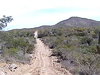
Straight road
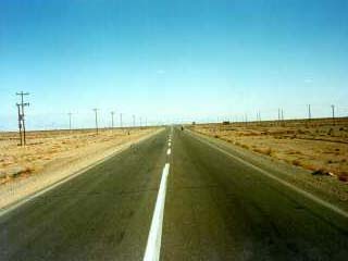 |
Straight road The easiest case, but we need to detect obstacles a long way ahead. |
The simplest case, but we have to go fast.
- Waypoint data indicates general direction and allowed tolerance.
- CMU-type visual road-follower keeps vehicle on on the road
- Long-range laser rangefinder verifies flatness of road surface.
- Eaton VORAD radar stops for above-ground obstacles.
Winding road
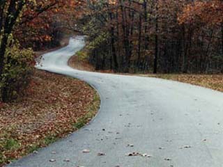 |
Winding roads We might just be given waypoints at either end of the road. If the road goes roughly in the right direction, that shouldn't confuse a simple road-following system like the CMU one. |
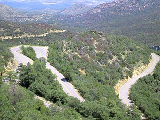 |
But do we have to handle something like this? Probably. |
 |
We'll almost certainly have to handle roads like this. |
Unclear at this time if the waypoint data is good enough that we don't need to reference maps.
- Waypoint data, with additional waypoints from maps and planning, indicates desired current heading to within 15-20 degrees.
- CMU-type visual road-follower keeps vehicle on on the road
- Long-range laser rangefinder verifies flatness of road surface on straight sections.
- Vehicle slows down when road curves because long-range rangefinder looks only straight ahead.
- Short-range rangefinder verifies flatness of road surface on curves, but only out to 10 meters or so, limiting speed.
- Eaton VORAD radar stops for above-ground obstacles.
Turn at waypoint near road intersection
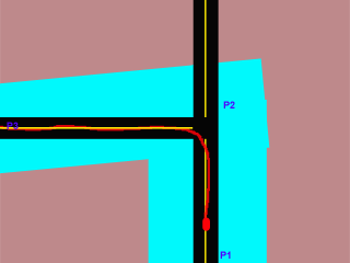 |
Turn at an intersection We're given waypoints P1, P2, P3 and an allowable deviation from them. Those define the area in blue. There's no guarantee that P2 will be within the intersection, and assuming ordinary non-differential GPS accuracy, it probably won't be. It's our job in this situation to find a path similar to the one shown in red. |
 |
Intersections tend to have visual clutter. Finding the side road may be tough. |
For intersections, we need good map data. Good enough that we can find the middle of the intersection to within a few meters.
Underpass
 |
Underpass Some sections of an underpass might not have enough clearance. Detect, back out, mark as impassable and try again. |
Here, the big issue is detecting that we're headed for a too-small opening before we're stuck in it. The laser rangefinder and the mapping system should be able to handle this. The laser rangefinder has to see a bit above the horizon, maybe 5 degrees. Some backing and filling might be needed to get through something like this.
Off-road
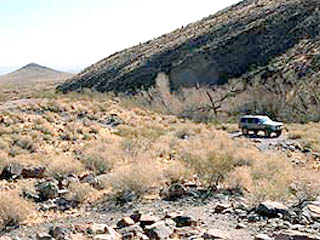
Simple obstacle
 |
Typical obstacles Miscellaneous obstacles in the desert. Even if we're supposed to be on the road, it's not too clear where the road is. |
 |
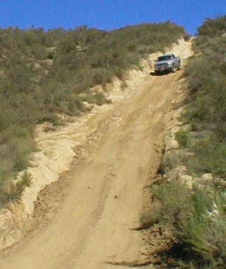
Impinging shrubbery We can't let ourselves be stopped by one overhanging branch. Yet we can't go plowing through solid obstacles. |
 |
Tight fit We should be able to handle a tight fit like this. It's a good test. The hardest part will be avoiding overreaction to the projecting branches. We can't see alongside, and our map is coarse. More short-range sensors on the sides? Feelers? |
These are both difficult situations. Deciding what we can plow through safely will be very tough. We're going to have to be able to inch through scrub. What sensors do we need?
Broken terrain
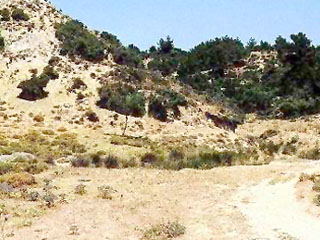
 |
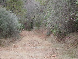
Rocky desert hillside Rough, but we may have to pick a route through it. We might not have to face anything this tough. |
 |
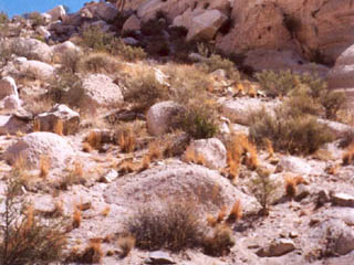
Rocky flats But we should be able to handle terrain like this. |
Steep hills
 |
Our throttle and braking control system has to be smart enough to not overdo the controls on steep downhills like this. (We can try this one. It's in the Hollister Hills Off-Road Vehicle Park.) |
The key here is using the accelerometers to keep accelerations within the slip limits. The ABS/StabilTrak system will help us if we get a little out of range.
Gullies
 |
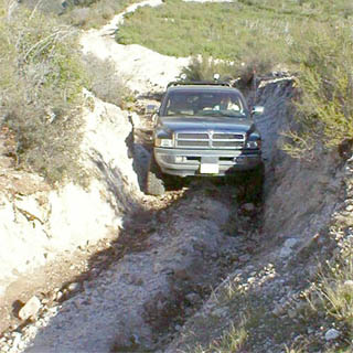
Gully Go through, or go around? |
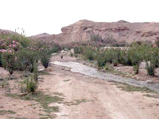 |
Wadi What about water? "The race will not be postponed on account of weather", the rules state. We're likely to encounter shallow crossings like this. |
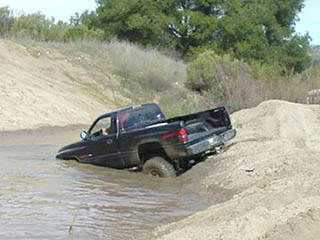 |
Deep water The shallow crossing above looks a lot like the one at left. How do we tell the difference? (Another Hollister Hills location.) |
We need to be able to avoid driving through deep water. But we may have to cross shallow water. We are going to need the ability to inch into water without getting in too deep. A water sensor in the front brush guard will help. We need to be cautious about descents that suddenly transition to a flat surface, and approach them slowly. We can't tell water from land until we reach it, but we can recognize bank-to-water transitions. Worst case is not the deep water above; we'd be inching forward in a situation like that. Worst case is the wadi, water approached from near-flat land. The odds are against something like that becoming deep rapidly.
We thus need two water sensors. One detects that we're getting in too deep, and the other detects that we're over water. The first is easy enough, but how do we do the second? Detect spray behind the tires? Measure distance to ground at wheels?
Miscellaneous
Checkpoint
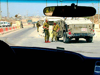 |
Checkpoint When do we stop? Do we park, or what? If so, where? We're not allowed to touch the vehicle at a checkpoint. |
 |
Worse, the checkpoint might look like this. We have to make sure we don't run people down. |
We need a bit more guidance from the organizers on this.
Other vehicles
What do we do about other vehicles on the course? Treat them as obstacles, probably. The start will be staggered; we probably won't see another vehicle unless it's stuck.